A list and/or spatial map of the sites where the organisation has assets and/or activities: In its direct operations and upstream and downstream value chain(s), where material nature related dependencies, impacts, risks, and opportunities have been identified, and whether any of these sites meet the criteria for sensitive sites; and; In its direct operations and, where possible upstream and downstream value chain(s), that are in sensitive sites. Other sites where the organisation has potentially material nature-related dependencies, impacts, risks and opportunities.

Cerulean Warbler
Near Threatened
IUCN Red List of Threatened Species
How IBAT can support nature-positive goals
IBAT provides fast, easy access to global biodiversity data and reports, helping your business assess biodiversity risks, inform sustainability strategies, and meet key disclosure requirements.
Access the world’s most authoritative biodiversity data
We offer a range of options, from one-off analysis and reporting, to subscriptions supported by our expert team, technical add-ons, and more.
Book a short call with our team to explore how we can support your requirements. Find out more about pricing and collaborations.
IBAT is powered by world-class, authenticated biodiversity data, informed by hundreds of the world’s leading scientists and experts.
Biodiversity Risk Screening
Assess biodiversity-related risks across project sites, supply chains, and investments to make informed, decisions. Identify critical habitats in line with IFC Performance Standard 6 and World Bank ESS6, support excellence in global project planning and risk management.
Biodiversity Disclosure
Support due diligence efforts with accurate, science-based biodiversity insights. Streamline your sustainability reporting and regulatory compliance programmes by integrating data into disclosure frameworks such as TNFD, CSRD, and GRI.
Biodiversity Strategy
Ensure responsible site selection and policy alignment with global conservation priorities. Strengthen your biodiversity commitments by identifying and avoiding development near sites important for biodiversity such as Alliance for Zero Extinction (AZE) sites and UNESCO World Heritage Sites.
Nature Positive Opportunities
Align your business operations with a nature positive approach to drive sustainable impact. Identify opportunities to help progress global conservation goals with STAR (Species Threat Abatement and Restoration).
IBAT Platform features
Using the IBAT platform you can access this data and generate tailored global biodiversity insights.
.png)
Upload site information easily
Do you have a list of sites you would like to plug into the platform?
Upload large portfolios of your project sites, supply chains, and investments in bulk choosing from a range of formats including ESRI, KML, KMZ or Excel.

Access global spatial data
Download GIS (Geographic Information System) shapefiles for IUCN Red List species, Protected Areas from the World Database of Protected and Conserved Areas (WDPCA), and Key Biodiversity Areas (KBAs) for custom analysis.
Do you require automated access to the latest monthly dataset updates? Leverage our API (Application Programming Interface) to ensure you always have the most up to date information at your fingertips
Generate biodiversity reports
Ensure alignment with biodiversity strategies and support Nature Positive commitments with clear, actionable insights. Download tailored reports for biodiversity risk assessments (PS6, ESS6) or disclosure requirements such as GRI (Global Reporting Initiative), TNFD (Taskforce on Nature-related Financial Disclosures) and CSRD (Corporate Sustainability Reporting Directive)
Visualise your biodiversity footprint
Easily assess potential risks and inform strategic decision-making. Generate maps to view your sites in relation to biodiversity-sensitive areas, including Protected Areas and Key Biodiversity Areas.
Reports
IBAT offers a variety of reports to suit all of your reporting needs. All reports can be accessed via Pay As You Go or as part of one of our subscriptions.
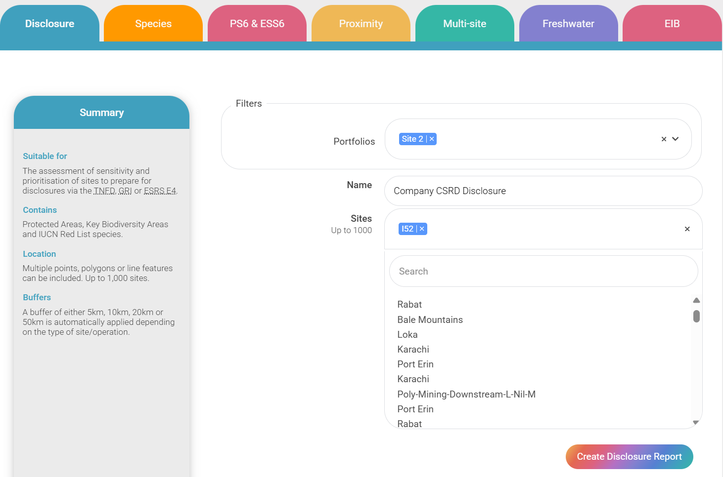
DISCLOSURE

Suitable for - Assessment of sensitivity and prioritisation of sites to prepare for disclosures via the TNFD, GRI or ESRS E4
Contains - Protected Areas, Key Biodiversity Areas and IUCN Red List species
Location - Multiple points, polygons or line features can be included. Up to 1,000 sites
Buffers - A buffer of either 5km, 10km, 20km or 50km is automatically applied depending on the type of operation
PROXIMITY
Suitable for - High-level early stage biodiversity risk screening
Contains - Protected areas, Key Biodiversity Areas & IUCN Red List Species
Location - Single
Buffers - User specified
PS6 & ESS6

Suitable for - High-level early stage biodiversity risk screening against IFC and World Bank performance standards
Contains - Protected areas, Key Biodiversity Areas & IUCN Red List Species
Location - Single
Buffers - Defaulted to 50km
Likelihood of Critical Habitat flagged
SPECIES

Suitable for - Identification of opportunities to reduce species extinction risk
Contains - IUCN Red List Species (Birds, Mammals, Amphibians, Reptiles)
Location - Single
Buffers - user specified
Unlimited calibration
FRESHWATER

Suitable for - High-level early stage biodiversity risk screening of projects with potential to impact on freshwater ecosystems
Contains - Freshwater species upstream and downstream of a specified location
Location - Single
Buffers - Select upstream and downstream
MULTI-SITE

Suitable for - Incorporating biodiversity into annual sustainability reporting (e.g. reporting against GRI or SASB standards)
Contains - Protected areas, Key Biodiversity Areas & IUCN Red List Species
Location - Multiple
Buffers User specified
Recognised across key biodiversity frameworks
Leveraging IBAT data ensures that your organisation stays at the forefront of credible biodiversity data insights, analysis, and reporting. IBAT is cited by major frameworks, including CSRD ESRS E4, TNFD,GRI, CDP, and the Science Based Targets for Nature.
GIS DOWNLOAD
Suitable for - Complete spatial data for a specific region of interest
Contains - Choose from either Core Datasets (IUCN Red List, WDPA, WDKBA) or Derived Datasets (STAR & Rarity-weighted species richness)
Location - Up to 1,000,000 km2
GLOBAL DATABASE
Suitable for - Complete global spatial data
Contains - Protected areas, Key Biodiversity Areas & IUCN Red List Species
Only available to Enterprise subscribers
Additional Information
Disclosure
PDF Reports
2 PDFs with results for reporting in line with TNFD and GRI:
The first PDF contains the assessment of all sites as in or near ecologically sensitive locations according to the aligned definitions provided by the TNFD and GRI and an example prioritisation of sites.
The second PDF contains further information on sites ordered by potential priority.
1 PDF with results for reporting in line with ESRS E4:
The PDF contains the assessment of all sites as in or near biodiversity sensitive areas according to the definition provided in the ESRS and an example prioritisation of sites. The PDF also contains IBAT information to meet other relevant disclosures within ESRSE4, for example information on supplier sites located in risk prone areas.
Excel Files
Full attribute lists of Protected Areas and Key Biodiversity Areas including distance from site and overlap with site.
IUCN Red List species found potentially found within 50km of each site and the maximum STAR scores for each site. Overall results showing which sites are sensitive and risk prone according to the different definitions provided by the TNFD, GRI, and ESRS E4 to aid comparison.
README
1 README PDF file containing an overview of the methodology, the definition of terms, the IBAT platform, limitations, a disclaimer, and recommended citations.
1 README tab in the excel file explaining the different data points.
Use Case
The provision of results which can be used when reporting in line with the TNFD, GRI or ESRS including the assessment of sensitivity and prioritization of sites.
Learn more
Our conservation team will be in touch via email. They can explain the reports in-depth and our various subscription packages.
Proximity
PDF Report
Summary of Protected Areas and Key Biodiversity Areas overlapped for each buffer and IUCN Red List of Threatened Species for a 50km buffer.
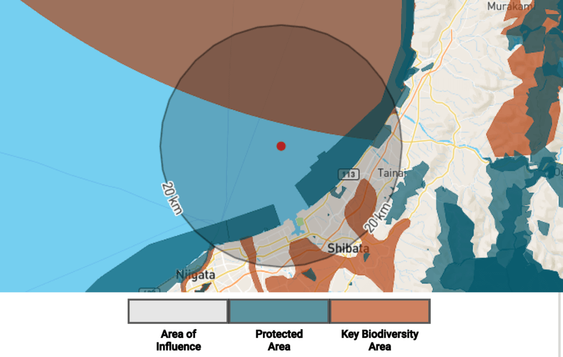
PNG Files
Two .png files showing the outline of the site and chosen buffers in relation to Protected Areas and Key Biodiversity Areas.
CSV Files
Full attribute lists of Protected Areas and Key Biodiversity Areas for each buffer selected and IUCN Red List Species for a 50km buffer.
README
A README file containing an overview of the IBAT platform, limitations, a disclaimer and recommended citations.
Use Case
High-level early stage biodiversity risk screening for a single site.
Buffers
Select up to three buffers between 1km and 50km for your geometry.
PS6 & ESS6
PDF Report
Summary of Protected Areas and Key Biodiversity Areas overlapped for 1km, 10km and 50km buffers, as well as their likelihood to trigger critical habitat. IUCN Red List Species within a 50km buffer and restricted range species.
PNG Files
Two .png files showing the outline of the site and buffers in relation to Protected Areas and Key Biodiversity Areas.
CSV Files
Full attribute lists of Protected Areas and Key Biodiversity Areas for each buffer and IUCN Red List Species for a 50km buffer.
README
A README file containing an overview of the IBAT platform, limitations, a disclaimer and recommended citations.
Use Case
High-level early stage biodiversity risk screening for a single site with specific reference to PSS6 and ESS6.
Buffers
Predefined at 10km and 50km.
Species
PDF Report
Includes:
Executive summary; site threat abatement importance; national and global testing; threat summary; species summary.
Visual map displaying STAR threat variation across the site. Breakdown of estimated threats impacting species in the site. Breakdown of estimated species contributing to STAR score in the site.
Summary of supplementary information and additional resources.
Highlights of 10 species which contribute the most to the estimated STAR score of the site with information on their assessments, threats and conservation actions.
Excel Files
Excel file containing tabs of STAR Threat Breakdown.
STAR Species Breakdown.
STAR species × threats matrix down to IUCN Threats Classification Scheme (Version 3.3) level 3 where available.
README
1 README PDF file containing an overview of the methodology, the definition of terms, the IBAT platform, limitations, a disclaimer, and recommended citations.
1 README tab in the excel file with descriptions of each different data points.
Use Case
Identification of opportunities to reduce species extinction risk.
Read FAQs for further information.
Freshwater
PDF Report
Summarises freshwater species in hydrobasins upstream and downstream of a specified location within the specified buffers.
CSV Files
One file for each of the buffers specified (as well as the exact site basin) containing IUCN Red List species for a 50km buffer.
README
A README file containing an overview of the IBAT platform, limitations, a disclaimer and recommended citations.
Use Case
High-level early stage biodiversity risk screening for a single site with potential to impact freshwater ecosystems.
Buffers
Select four buffer ranges to be assessed both upstream and downstream of the given location.
Multi-site
PDF Report
Protected Areas, Key Biodiversity Areas and IUCN Red List Species visualised and compared across a portfolio of sites. Includes total and mean STAR Threat Abatement and Restoration Scores for each site.
CSV Files
Five files detailing the Protected Areas and Key Biodiversity Areas within chosen buffer of each site, IUCN Red List category counts for each site, total and mean STAR scores for each site and a summary overlaps table.
README
A README file containing an overview of the IBAT platform, limitations, a disclaimer and recommended citations.
Use Case
Incorporating biodiversity into annual sustainability reporting (e.g. reporting against GRI or SASB standards).
Buffers
Select a single buffer to be applied to all sites.
Empowering your world-shaping decisions
Our global users range from those with a lot of experience working with Global Information Services (GIS) and other data files to those completely new to it.
Investment in the future of our planet
Subscription fees are invested into the maintenance and development of critical global biodiversity datasets: the IUCN Red List of Threatened Species, the World Database on Protected and Conserved Areas, and the World Database of Key Biodiversity Areas.

Testimonials
Hear what our users have to say...
"IBAT provides essential screening on threatened species and endangered habitats that helps us assess risks, focus accompanying investigations, and prioritise restoration activities at our operating sites globally."
"IBAT has been an essential tool to help Evonik understand our biodiversity risks and opportunities on-site."
"IBAT provides up-to-date information on protected area designations and threats to habitat and biodiversity. These data inform the BeZero Carbon Rating, an assessment of the likelihood that a carbon credit delivers on its promise to achieve a tonne of CO2e avoided or removed."
"The outcomes have served several purposes from the CSRD disclosure to the launch of specific biodiversity conservation projects. IBAT is a powerful tool which has definitely help LVMH and its Maisons making the biodiversity Group’s strategy more reliable and science based.”
"IBAT also allows me to integrate my analysis with other GIS tools, which increases the depth of my scrutiny. We are looking forward to utilising the new STAR functionality!"
"IBAT provides an excellent pre-screening desktop resource to be used in these assessments focusing on species, habitats and legally protected and or internationally recognised areas of biodiversity importance."

Learn how IBAT can transform your relationship with data and support your nature-positive goals